
Pilgrimage to Pallett Creek
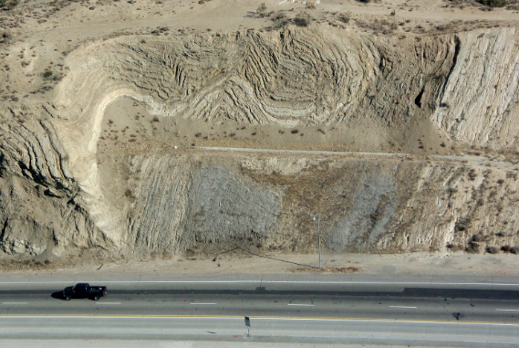
Tight folding, like a crumpled rug, of the 2 m.y. old beds just north of the San Andreas fault
I heard they exploded the underground blast
They say its gonna happen – gonna happen at last
That’s the way it appears
They tell me the faultline runs right through here
So that maybe that may be
What’s gonna happens gonna happen to me
They tell me the faultline runs right through here
Atlantis will rise, Sunset Boulevard will fall
Where the beach used to be won’t be nothing at all
That’s the way it appears
They tell me the faultline runs right through here
—”Mama” Cass Elliott, California Earthquake
Last week I had the opportunity to take my intro geology class on a field trip along the San Andreas fault, from Palmdale to Devil’s Punchbowl. It’s always an eye-opening experience for students to see what the REAL San Andreas fault looks like. Contrary to the Hollywood myths of a giant chasm filled with glowing lava that Superman could pull back together (in the first Christopher Reeve Superman movie) , the real fault is so subtle that thousands of people drive across it twice a day on the 14 freeway between Palmdale and LA and never notice it. Most faults in southern California are strike-slip faults where one block shifts horizontally relative to the other, with almost no vertical displacement. They grind past one another each time there is a quake, and pulverize the rock between them—but there is no “gap” or “chasm” opening up. This pulverized rock is easy to erode, so stream valleys tend to follow fault lines. Consequently, faults in this region (and in most regions) are simply long straight valleys that look unimpressive at ground level. However, when you see them from the air or satellite view, they are glaringly obvious. So you have to know where and how to look, and then the long straight valleys begin to stand out. Since there are so many faults in Southern California, I always tell my students that any long straight feature (valley or scarp) in the area is assumed to be a fault unless proven otherwise!
Once you know where to look, the San Andreas is easy to spot. There’s a pullout on the northbound Hwy. 14 (Lamont Odett overlook) where you can park safely and stand above the valley of the San Andreas, and visually follow it across the landscape. Immediately in front of you is a former sag pond (natural bodies of water accumulating along fault zones as water percolates up the fault barrier), which has been dammed to form Lake Palmdale. Then you look to your east and see the big notch on the north flank of the San Gabriel Mountains where the fault cuts through, and the town of Wrightwood is located. I explain to my students that during the 1857 Fort Tejon earthquake, the entire Pacific Plate (southern) side of the fault on which we are standing jumped about 30 feet to the northwest in a matter of seconds. Since then, that stretch of the San Andreas (from about Taft down to Palm Springs) has been locked for over 156 years. Seismologists expect that when this part of the locked San Andreas finally moves, it will again jump 20-30 feet, all the roads and structures that cross it will be offset by at least that much (including almost all the roads out of LA, including I-5, I-15, and Hwy. 14), and the damage to Palmdale and the other towns near the fault will be catastrophic. (Ironically, the bronze plaque at the overlook does mention the fault and the Ft. Tejon earthquake—but gives its date as 1957, not 1857!)
I usually take my field trip through the roadcuts just north of the fault on Hwy. 14, where they can see the Pliocene Anaverde Formation (an old sag pond deposit formed only 2 m.y. ago) all crumpled and folded like a huge collapsed carpet by the pressure of the fault zone just to the south. Then we take Avenue S along southern Palmdale, noting all the houses and buildings built directly on the fault zone, or within a mile of it, blissfully unaware of their danger. (I’m sure no realtor mentions it!). Many have heavy Spanish tile roofs, whose weight is much more likely to make the house sway and break up during a quake. We also see the California Aqueduct, built to bring water to LA from the northern Sierras, which crosses the fault in this area (as it must do somewhere). Fortunately, it was engineered with seismic gates along its length, so if one section is ruptured, the gates will confine the spill to just a small segment of the aqueduct, and prevent all the water from flooding out. Still, after a big quake LA will be without water from two of its three major aqueducts for a long time, and water will become our most precious commodity.
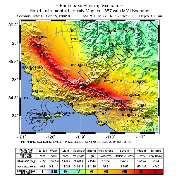
Map showing the location of the San Andreas fault and when each segment last broke. Pallett Creek is in the middle of the orange segment. Parkfield is labeled as well.
Our road follows the fault zone or travels just north and parallel to it along Pearblossom Highway, Ft. Tejon Road, and through Little Rock (California, not Arkansas), until we come to the spectacular Devil’s Punchbowl, where the Punchbowl Formation (8-11 m.y. old) is crumpled into a tight syncline as it is caught between the San Andreas to the north and the Punchbowl fault zone at the base of the San Gabriel Mountains. We usually spend the midday at the Devil’s Punchbowl, have our lunch in the nice picnic area, study the fold and the outcrops closely, then hike down to the bottom where we find that the pebbles in the old rocks don’t match those eroding out of the modern San Gabriel Mountains above us. At that point, I explain that my former undergrad advisor, Mike Woodburne of University of California Riverside, was one of the first to figure out that the pebbles of the Punchbowl Formation come from rocks near Victorville in the Mojave Desert (the Sidewinder volcanics), and that the entire Punchbowl Formation has slid northward over 100 miles in the past 8 million years from near San Bernardino to its present location. This really blows the minds of the brighter students who are paying attention!
But the highlight of the afternoon is a stop at Pallett Creek, just northwest of the Devil’s Punchbowl. Mention the word “Pallett Creek” to any geologist or geophysicist in the region, and they immediately recognize it, because it is the Mecca of Paleoseismology—the first place where scientists realized that they could trace and date ancient earthquakes in an effort to predict future quakes. At Pallett Creek, there are sag pond deposits that have covered the San Andreas fault for over 2000 years, now uplifted into a terrace as the creek cuts down. In the late 1970s, Stanford Ph.D. student (and now Caltech professor) Kerry Sieh had the bright idea of using backhoes to dig big trenches through these old pond deposits. Once the walls of the trenches are exposed, you can carefully photograph and map the layers going across. As you do so, there are many exposures that show ancient faults that cut some of the lower, older layers, but are then buried by the upper layers. Thus, you can constrain the age of that particular fault by the youngest layer it cuts, and the oldest one that is not cut. All that is needed is dates on the layers, and these are provided by the fragments of charcoal or actual peat layers (when the pond was swampy), which are datable by radiocarbon. Once Sieh got his radiocarbon dates back from the lab, he was able to bracket the age of over 20 prehistoric earthquakes in the past 2000 years. Originally, he got an age estimate of 137 ± 8 years between quakes on this branch of the San Andreas, then later published a revised estimate of 145 ± 8 years. Recent redating using new radiocarbon methods gives an estimate of 135 years. Either way, the fault has not moved in 156 years, outside the error limits of the current dating of past quakes. No wonder seismologists are so worried about this part of the San Andreas that is way overdue to break, a “seismic gap” in their parlance.
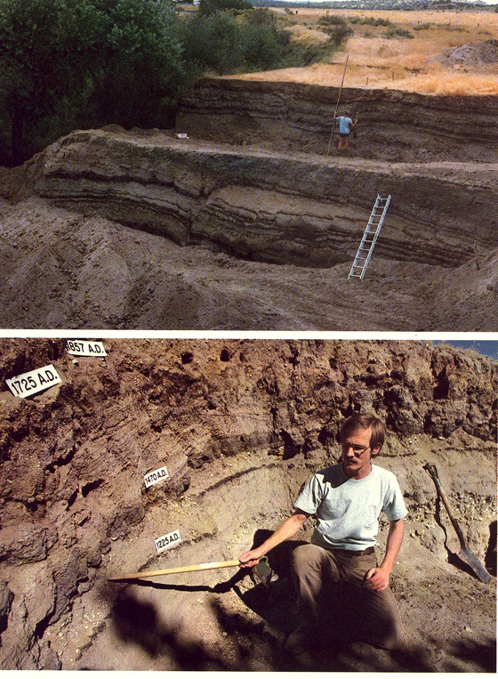
(Top) Image of Pallett Creek trenches when they were first dug. (Bottom) Kerry Sieh demonstrating the offset in the black layers datable by radiocarbon; the labels give the radiocarbon ages. Sieh is pointing to a layer that was ruptured by a fault before 1470 A.D., but since 1225 A.D.
However, faults are not quite as regular and clock-like as we would like. The most “predictable” stretch of the San Andreas, near Parkfield in the central California Coast Ranges, was due to move in 1988. Huge efforts were expended to have every instrument in place and be there when it happened. Then all was quiet for 14 years. Eventually, it moved in 2002, long after everyone had left. Luckily, all the equipment is still in place, since it is remotely monitored by satellite by the scientists at USGS in Menlo Park, and has its own batteries and solar collectors and satellite antennae, so the only people who need to visit Parkfield are the technicians who maintain the equipment.
When I started teaching here in the late 1980s, many of Sieh’s original trenches were still visible. We could take large groups of Occidental students on a field trip, break them into groups to study each different trench face, have them interpret the evidence and then report back to the group what they found. But the soft sediments of the trench walls erode easily, so by the 1990s and the 2000s, the trenches were so badly collapsed and eroded that it was pointless to stop and visit them. Then last year a group at the San Bernardino County Museum led by Kathleen Springer ran some trips along the San Andreas fault, and went out to Pallett Creek and dug out and refreshed one of the key trench walls. Now I can take a group of students there and show them where history was made.

One of the Pallett Creek trenches as it looks day, freshly redug
My students don’t really appreciate how important this place is, but Pallett Creek and its trenches launched an entire discipline now known as paleoseismology, the study of ancient earthquakes. Many geologists do this kind of research now, digging trenches across active fault zones wherever they can find suitable conditions. Millions of grant dollars are available for this kind of research, which employs hundreds of scientists. The techniques have evolved a lot since Sieh’s first trenches. Now they carry huge hinged folding aluminum braces that they can put right in the trench and lock into place, preventing the walls from collapsing. To make the most of their limited time when the trench is finished, they mark all the layers and faults with various colored flags and markers, then photograph it in pieces, and digitally stitch all the partial images into one big panorama on their computers to see the entire trench face in a way that would be impossible in the field. And the results have been incredibly important in establishing which fault zones are the most active and dangerous, and allowing us to make realistic predictions of which fault zones have the highest probability of breaking in the near future. We still cannot predict earthquakes to the nearest day or even month, but this is a big improvement over what we used to know!
A very interesting and entertaining post. It’s always fascinating to get a tour of a particular region from someone who knows the geology and prehistory of the place.
Thanks for a tremendously interesting post! I know most of those places really well because I was an outdoorsman and lived in Lancaster for many years. However- I have not been to Palette Creek. I will have to check it out some time.
I always wondered why the strata in the rock formation on the 14 Fwy were so contorted. Your explanation makes a lot of sense :-)
I am sure you are aware of the new piece of research – a hypothesis really – which argues that the San Andreas structure is more complex than earlier thought. Apparently the possibility exists that an older tectonic plate may lie buried beneath the current plate structures. I have no idea how widely this new idea is accepted/rejected by the geology community. If it is true, though, it might explain why the fault system is locked up on that region of the San Andreas. Maybe it is necessary for the deeply-buried plate to also fracture in order for that part of the fault to move. In other words, the older plate is acting like a mechanical interlock. If this idea is accurate, it could imply a very big release of energy when the whole system finally breaks. By the way – I was under the impression that the region of most serious concern is the part of the fault line near Banning (on the 10 Fwy near Palm Springs). Am I wrong about that??
Pete, Redondo Beach
By the way … two things:
1. Your Web site has stopped taking messages from people using Proxy servers. However, many private companies use firewalls that effectively make their outgoing messages seem like they are coming from proxy servers. So you are screening out valid messages with this policy.
2. I went back and took a look at all the earthquake data for Southern California over the last 100 years. I started by focusing on large quakes (greater than 6.0 magnitude). I looked at the frequency of those quakes over 25-year intervals. The So Cal region typically gets about 5-6 large quakes every 25 years. The data are fairly good for this frequency of quakes. There are some blips in the data of course. For example, the period 1925-1949 actually had 8 large quakes. But in general the frequency number of 5-6 quakes is not bad as an estimate.
There is one BOG problem. During the time period 2000-2013 we have only had one big quake. And in fact that was actually south of the US-Mexico border (the Mejor quake). This means that the previous decade has been unusually low in producing large quakes for So. California.
If the data I am quoting you are right – and I see no reason to doubt them- then Southern California could be looking at experiencing 4-5 large quakes in the next twelve years. That will really get peoples’ attention. That number of quakes in the magnitude 6-7 energy range will do a fair amount of damage and cause significant insurance losses.
We have been lulled into a false sense of security by the recent period of low earthquake activity in So. California. I am still looking at the earthquake data some more – to see if better probabilistic models can be constructed for what is already known.
regards,
Pete, Redondo Beach
The author of “California Earthquake”, John Hartford, wrote another apocalyptic folk song during the same era – “I’m Still Here”, performed by the Smothers Brothers on their television show.
Now trains are runnin’ towards each other.
Shotguns are pointed at my head.
Tornado clouds are formin’ o’er the crossroads.
H-bombs are fallin’ towards my bed,
But I’m still here.
I’m still here. Now, how ’bout that?
My city may be fallin’
But I’m still here
Ironically the show went off the air shortly thereafter. The author passed away in 2001 and is only iconically Still Here, as is “Mama” Cass. Any way you look at it though, “Mama” has a larger icon (as do the Smothers Brothers).